

Geneva Policy Forum — Policy Brief
Prepared for: Geneva Policy Forum Date: September 2026 Subject: The intensifying 2026–2027 El Niño event and its implications for global climate risk management, trade, food security, and vulnerable populations.
1. Executive Summary
The world has entered what UN Secretary-General António Guterres has called a « danger zone of extreme weather » as a rapidly intensifying El Niño takes hold across the tropical Pacific. According to the World Meteorological Organization (WMO), the current event is on track to be the strongest in more than 70 years — potentially since records began in 1950 — and is expected to persist through at least February 2027 .
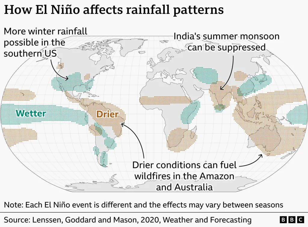
The consequences are global and asymmetric: drought and wildfire in South East Asia, Central America and parts of South America; stronger typhoons and displacement in East Asia; flooding in eastern Africa, southern Brazil and the southern United States; and disruptions to critical trade arteries such as the Panama Canal. Crucially, these impacts are layered on top of human-induced climate change, amplifying heat, marine heatwaves, and the vulnerability of communities least equipped to cope .
This brief argues that while early warning systems and pre-emptive mobilisation have improved significantly since the last major El Niño, the structural drivers of vulnerability — fragile infrastructure, exposed housing, weak healthcare and sanitation systems — remain unresolved. Geneva Policy Forum participants should treat the current event as both an immediate humanitarian challenge and a stress test for longer-term climate resilience policy.
2. The Science: An Unprecedented El Niño
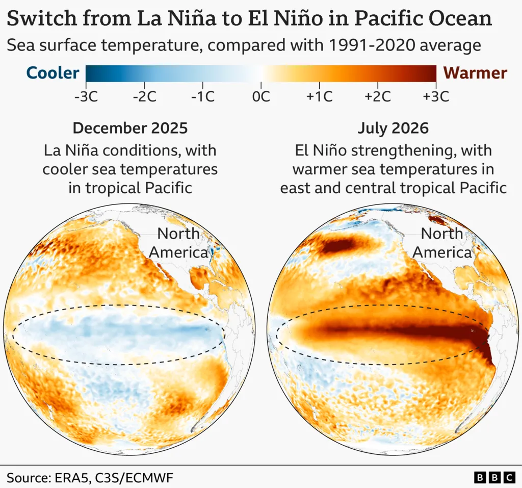
El Niño is a natural climate phenomenon driven by a weakening of Pacific trade winds, which allows warm water to spread eastward across the central and eastern tropical Pacific, releasing heat into the atmosphere. It typically alters global weather patterns, pushing some regions into drought while others experience heavier rainfall, stronger storms, and flooding .
What distinguishes the 2026–2027 event is its intensity and the speed of its development:
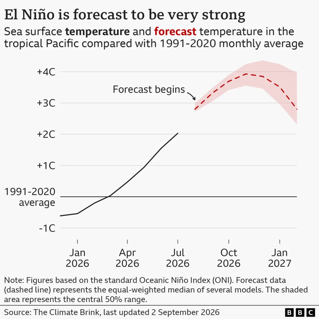
- Sea surface temperatures (SSTs) in the key Niño 3.4 monitoring region have risen sharply, exceeding +2 °C above the 1991–2020 average in recent weeks and reaching weekly values of approximately +2.2 °C to +2.6 °C by mid-August 2026 .
- Seasonal-average SST anomalies are forecast to reach approximately 2.9 °C during August–October 2026, with the intensification trajectory peaking around November .
- Monthly sea surface temperatures could approach +4 °C above average, which would make this the strongest El Niño since at least 1950, by potentially a large margin .
- Sub-surface temperatures are even more exceptional, in places more than 8 °C above average .
The WMO’s latest El Niño/La Niña Update describes an « exceptionally high likelihood of nearly 100% » that the event will persist through February 2027 — the first time a WMO update has been so unequivocal, reflecting strong agreement across its global forecasting network .
Secretary-General Guterres framed the stakes plainly: « El Niño is being supersized before our eyes. The science leaves no room for doubt: the planet is in uncharted waters, and those waters are heating up. »
3. Compounding Drivers: Climate Change and Ocean Heat
This El Niño is not occurring in isolation. It is叠加 on top of long-term human-caused warming, which intensifies its effects. As Guterres warned, El Niño is « adding fuel to a planet already on fire — with scorching heat domes, apocalyptic wildfires and record hot seas. Fossil fuels are fanning the flames of this crisis. »
Two additional oceanic drivers are amplifying regional impacts:
- A positive Indian Ocean Dipole (IOD), which warms the western Indian Ocean relative to the east, is forecast to develop and can intensify drought, flood, and wildfire risk around the Indian Ocean basin .
- Above-normal sea surface temperatures are also expected in the tropical Atlantic and around parts of the Australian coast .
For marine ecosystems, these changes are acute. Australia, with its rich marine life, has been plagued by climate-driven marine heatwaves in recent years. While forecasts suggest the Great Barrier Reef may be spared the worst conditions this year, Southern Australia is « getting slammed, » according to Dr Alistair Hobday of Australia’s science agency. The last marine heatwave to hit South Australia and Tasmania brought starving penguins, fish kills, suffocating algae outbreaks, and jellyfish invasions .
Some scientists believe climate change may be making El Niño events themselves stronger, though this is not yet certain .
4. Regional Impacts: A Map of Disruption
4.1 Drought, Wildfire, and Trade Disruption
Drier-than-usual conditions are forecast across large areas of South East Asia, Central America, and northern South America, increasing drought and wildfire risk .
- Panama Canal: Anticipating lower rainfall, transit through the canal — used by roughly 14,000 ships per year and generating about $3 billion annually for Panama — is being reduced by more than 10%. This is a direct, measurable climate impact on global trade .
- Indonesia: Wildfires have burned more than 107,000 hectares nationwide this dry season, with a longer-than-usual fire season. Authorities are deploying cloud-seeding aircraft and have arrested dozens over allegations of using fire to clear land. Residents report thick smoke, stinging eyes, and persistent smog .
4.2 Stronger Typhoons and Displacement
- China is expecting seven typhoons to make landfall this year, a number its experts link to a « super El Niño. » In July alone, typhoons Bavi, Noul, and Maysak left dozens dead. In August, more than one million people were forced to evacuate as Typhoon Dolphin brought heavy rains and strong winds .
4.3 Flooding and Landslide Risk
Wetter-than-average weather is expected in parts of eastern Africa, southern Brazil, and the southern US, raising flood risk .
- Peru, Ecuador, and parts of Brazil are particularly vulnerable, with previous El Niño events bringing increased rainfall, flash flooding, and landslides — especially in urban centres where drainage is inadequate .
- Southern Africa, including countries such as Botswana, experienced severe drought during the last El Niño event .
5. Preparedness: What Is Being Done
Governments and international agencies are taking the threat seriously. Key measures include:
- WMO « major mobilisation »: The WMO has launched a concerted effort to circulate forecasts of potential El Niño-linked extreme weather to as many communities as possible .
- Early warning systems: Strengthened globally, including Australia’s new marine early warning systems — which allow time for financial relief for fisheries, relocation of crucial species, and increased coral monitoring .
- Pre-emptive medical assistance: The United States announced deployment of the vessel USNS Comfort to the Peruvian coast to provide additional medical and technical support ahead of the event’s peak .
- Community-level preparedness: Organisations such as Practical Action have worked with partners to improve public access to early warnings, including river levels, flood risks, and weather forecasts .
WMO Secretary-General Celeste Saulo warned that « El Niño has the potential to deliver a massive blow to communities and economies across the world, » and that « we are already seeing disruption and devastation from droughts and floods and we expect these impacts to increase as El Niño intensifies. »
6. The Structural Vulnerability Gap
The most important policy insight from the current event is captured by Miguel Aréstegui, climate resilience lead at Practical Action: El Niño « does not arrive in a vacuum. » While early warnings save lives, they do not address the deeper, structural conditions that turn a weather event into a humanitarian disaster .
These include:
- Housing in exposed areas — floodplains, landslide-prone slopes, and informal urban settlements.
- Fragile water and sanitation systems — easily overwhelmed by flooding or rendered useless by drought.
- Weak healthcare systems — unable to absorb the surge of climate-related injury, disease, and displacement.
Aréstegui’s framing is instructive for policy audiences: « We are significantly concerned, but that concern needs to translate into preparedness rather than alarm. » Preparedness, in this view, must extend beyond the immediate forecast horizon to the multi-year investments that reduce baseline vulnerability .
7. Policy Recommendations for the Geneva Policy Forum
- Scale and sustain early warning systems. The WMO mobilisation demonstrates that forecasts can now reach communities with high confidence. Geneva Forum participants should champion sustained, predictable funding for multi-hazard early warning systems — not as emergency measures, but as permanent infrastructure.
- Protect trade and supply-chain chokepoints. The Panama Canal reduction shows how climate variability translates directly into economic shock. Policy frameworks should assess and reinforce the climate resilience of critical maritime corridors.
- Invest in structural resilience, not just response. Housing, water, sanitation, and healthcare systems in exposed regions are the true determinants of disaster severity. International finance and development policy should prioritise these long-term, less visible investments alongside emergency response.
- Integrate marine and terrestrial monitoring. Australia’s marine early warning model — linking forecasts to financial relief, species relocation, and coral monitoring — offers a transferable template for coastal and island economies facing marine heatwaves.
- Address the root cause. As the UN Secretary-General has repeatedly emphasised, fossil fuel expansion is « fanning the flames of this crisis. » The current El Niño is a warning of a warming baseline; without emissions reductions, future events will be even more severe .
- Fund anticipatory action before impacts peak. With the event expected to peak around November 2026 and persist into early 2027, the window for anticipatory humanitarian and financial action is now. Pre-positioned funding outperforms reactive appeals.
8. Conclusion
The 2026–2027 El Niño is shaping up to be a defining climate event of the decade — potentially the strongest in modern record. It tests the world’s early warning infrastructure, its trade resilience, and its commitment to protecting the most vulnerable. The science is clear and the forecasts are unusually confident. The remaining question is whether preparedness will match the scale of the threat.
As the WMO and the UN have made clear, the race is now « between rising risks and our commitment to take climate action and protect people. » The Geneva Policy Forum is well placed to ensure that race is won .
References
- World Meteorological Organization (WMO), « El Niño set to become very strong, raising risks of extreme weather into 2027, » 1 September 2026.
- BBC News, « El Niño ‘supersized’ as countries race to prepare for extreme weather, UN warns, » 3 September 2026.
- Associated Press (AP News), « UN warns record strong El Nino will add fuel to a burning planet, » 31 July 2026.
- Reuters, « UN weather agency warns strong El Nino to intensify from August 2026, » 31 July 2026.
- UN News, « Strong El Niño ahead, UN weather agency warns, » 31 July 2026.
- The Guardian, « India’s monsoon rains in danger as UN chief warns planet is ‘on fire’, » 31 July 2026.
Additional supporting data: WMO Global Seasonal Climate Update, August–September–October 2026 ; WMO, « Strong El Niño expected to intensify, » 27 July 2026 .